
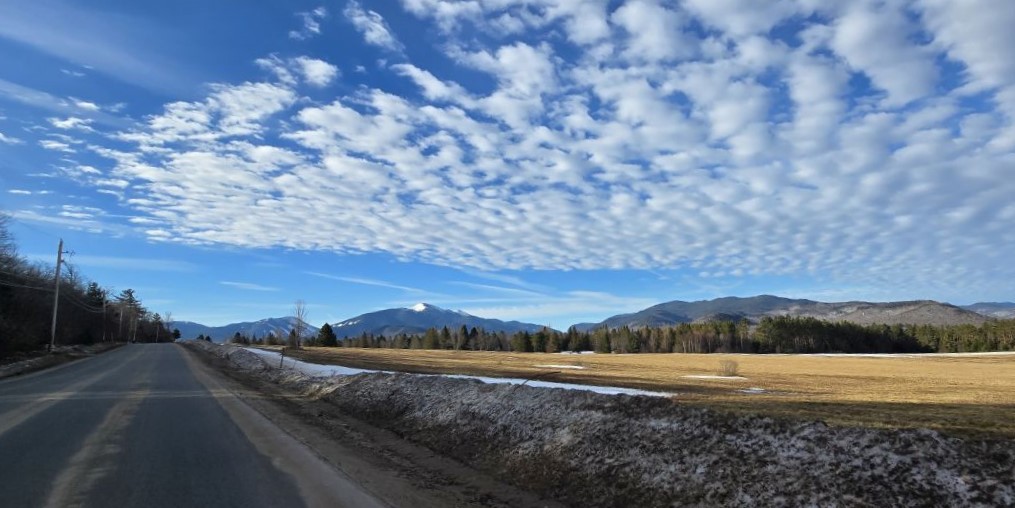
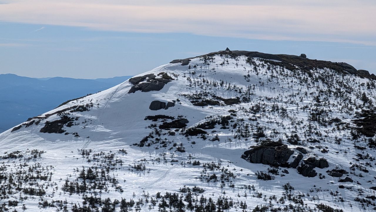
Monday dawned bright and beautiful. The forecast was calling for temps in the 40s and 50s throughout the day with a bit of wind. We were expecting at least some level of rotten snow and slush. I was personally quite concerned the big slides up Algonquin would be icy, but according to reports from the day before, these would be achievable without microspikes. Looking at Algonquin from the Loj road, it was clear the sun had been hard at work with snow shining on the North facing slopes and not much apparent on other parts of the mountain.
Thanks to Dan for taking the above photo and thanks to both Jay and Dan for sharing other photos I've used in this article.

The Loj lot was unsurprisingly sparse with cars when we arrived. We were on the move shortly after 9:30am with only one group on the trail ahead of us.
Sloppy Slog

At first we went out on bare boots. The trails within the ADK property were all ice and slush. I was kind of wanting my microspikes, but dumb hiker brain reasoned that the risks were worth avoiding the annoyance. I managed to stay vertical, fortunately.

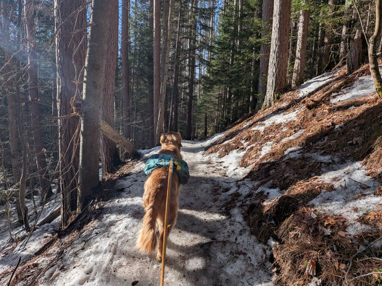
I took off Sunny's leash a bit sooner than usual, about when the trail started meandering across the PUDs and little stream crossings near the Northern tip of the range. It had been several weeks since Sunny's last hike up Mount Jo, so he was having the time of his life.
It was also about this time we put on our snowshoes. The snow was mushy, but deeper here. All of the stairs going Algonquin Trail were totally submerged, but some of the big stones on the sides of the stairways were starting to poke through.

"If you see a sleepy bear, leave it alone!"
Sloppy Climb

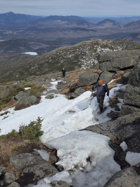
The monorail effect was definitely in play today. The group who climbed Algonquin yesterday had "found" the edge of the monorail several times while descending the mountain, for which we were eternally grateful. As we climbed, the snow got a bit more snow-y, but the first inch or snow of the surface was still rotten mashed potatoes.

The ledge before the campsite was actually a bit easier to climb in the snow since the slope was smoothed out with snowdrifts. Still, it was layered with the first real proper ice we'd seen.

Jay and Dan took the right side across the ice, while I hooked left, following Sunny's lead.

When we came to the MacIntyre Falls, we found it rushing with more water than I'd ever seen there. Still, it was completely passable. We enjoyed the falls and had a snack before pressing on.

The ledge immediately after the falls was a lot more difficult to negotiate than the previous one. I actually managed to get myself treed on the left. Rather than sliding down and admitting defeat, Jay helped me up to the snow while Sunny barked and whined at my plight. Dan chose the better route on the right, using the tree to pull himself up.
We were really feeling the climb by the time we came to the place where the trail reaches eye level with the peak adjacent Wright. Jay nicknamed it "Wrong Peak" which, I feel is quite apt. It's easy to get your hopes up at the little notch between Wrong Peak and the hard left turn up to the junction, because it makes you think you've made it to the col. Nope. We had another 300' to climb.
Interestingly, there's usually a wide chimney-like formation around here somewhere. I went back to my old hikes to see what it looks like, however I think this time of year it's so full of snow that it is nothing more than a huge drift you climb up without even noticing it.
Great Heights

We came to the Wright/Algonquin junction a little after 12:00pm, two and a half hours after we'd started. We were starting to feel the wind, so we donned a bit more gear. We took the time to fuel up for the big climb ahead of us.

"I can't help but notice you have something delicious in y... oh thank you Uncle Dan!"

We hung out for about half an hour, then we were on our way again. Sunny was quite restless just about every time we stopped today for some reason. I can't read dog brains, so I don't know if he is as eager for the summit as we are sometimes or if he's just expecting another snack when we get there. Maybe he's just got ants in his pants like his dog dad.

We quickly came to the endless big slide up Algonquin. Fortunately for us, the reports were true; the snow on the slide was loose enough for our snowshoes to grip. It was a little slushy, but that might have been working in our favor today. It won't be long before you'll need crampons for this ascent some days this month.
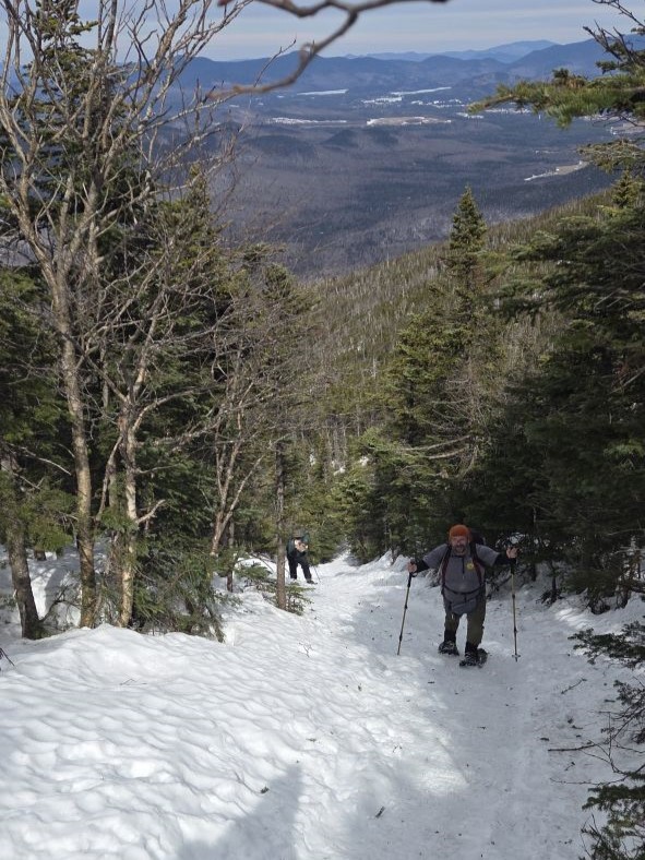
I actually didn't think the slide was all that difficult today. I really wanted to butt-slide down it on the descent, but I was dubious about the safety of such a maneuver. I figured we'd have plenty of other opportunities to practice and test the conditions prior to this so we could make an educated decision when the time came.

It was a bit of a slog meandering through the little trees just below tree line. It was here among the close, gnarly trees where we encountered our first spruce trap minefield. I learned today that the phenomenon of how trees grow near the summits is called the "Krummholz effect".
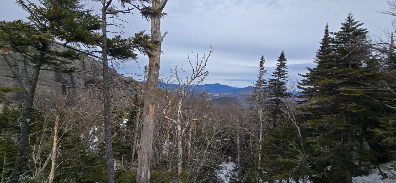
Despite the difficulty, there were still great views to enjoy as we climbed. One of the great things about snowshoeing the Adirondacks in the Winter is that you don't have to spend so much of your time watching your feet; you can actually enjoy the world around you without stopping!

It felt so good to be in the sun as we started to break tree line.

Sunny was delighted.
It was here at the start of the many rock ledges above tree line where the snowshoes came off. Jay asked if we were okay and I said yeah. He asked if we'd been screaming and I said I heard something but I thought it was the wind through the cairns or something. As we approached the summit, we heard it again, but we realized it was just the group that had come before us. They were howling into the 50-60mph winds.
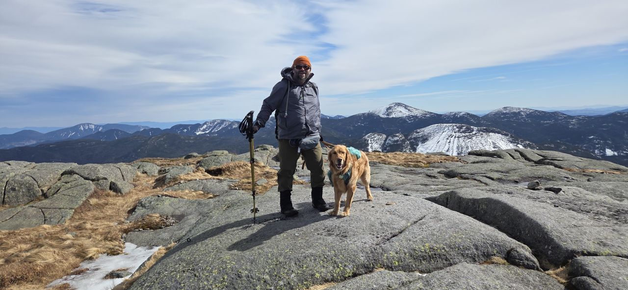
We made the summit a bit after 1:45. It was indescribably gorgeous up there and we drank it all in despite the incredible winds.

Sunny got lots of pets. His day was made.

We enjoyed the summit for a little while.

It had taken us quite some time to climb up from the junction, but Jay understands that Dan likes making great decisions and I like enabling him. We insisted on seeing what the views were like Iroquois today. Besides, what is the point of getting extra hour of daylight if you don't use it?
Joking aside, we knew the hike down would be lightning fast and we did still have plenty of daylight left. We set off around 2:50.
It's a Trap!

Boundary and Iroquois loomed in the distance. I do know Sunny should be on leash way up here, but he was dutifully staying on trail. I think he does understand where he should and shouldn't go. Training this into him hasn't really been a deliberate act, but I think years of leash-tugging and commands have ingrained it in him. It probably doesn't hurt that the smell of people and boots probably clings to the rocks in ways we humans can't detect.
The monorail picked up again as we descended into the col and it zigzagged around the trees. These trees are a bit taller than me in the warmer months. Today, the traverse across the ridge featured expansive views free from too much obstruction. It had probably been even nicer just a week prior.
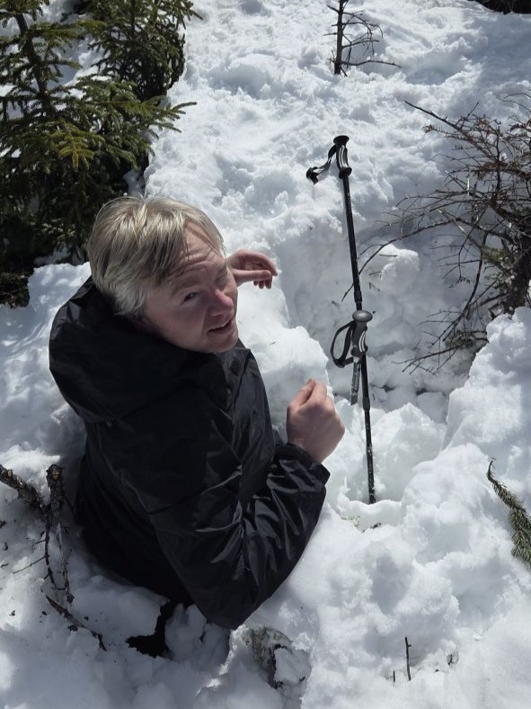
Unfortunately, the beautiful views and the age of the snow have the unfortunate effect of landing you in giant holes. I fell in a couple of spruce traps (or, more accurately, fir and spruce traps) on the way over and on the way back. Oddly, despite that, we only have pictures of the other two guys buried in snow and not myself.

We survived the minefield and it was a hell of a day.

The monorail was definitely not following the real trail. Instead, it was following a more direct route up and over Boundary.
We made quick work of the other spruce trap minefield between Boundary and Iroquois. We arrived at the summit at around 2:50, about an hour after we'd left Algonquin.

It was my first time on Iroquois with views and I must say it is absolutely stunning and 100% worth the walk over from Algonquin. You can damn near see everything from there. I daresay it might make for a really great 46er finisher peak, actually. Viewing everything, I was actually struck by how short Marshall looks compared to Iroquois. It's easy for me to think of this mountain as just a "bonus" peak to Al that I forget that means Iroquois is also still very tall compared to other High Peaks.
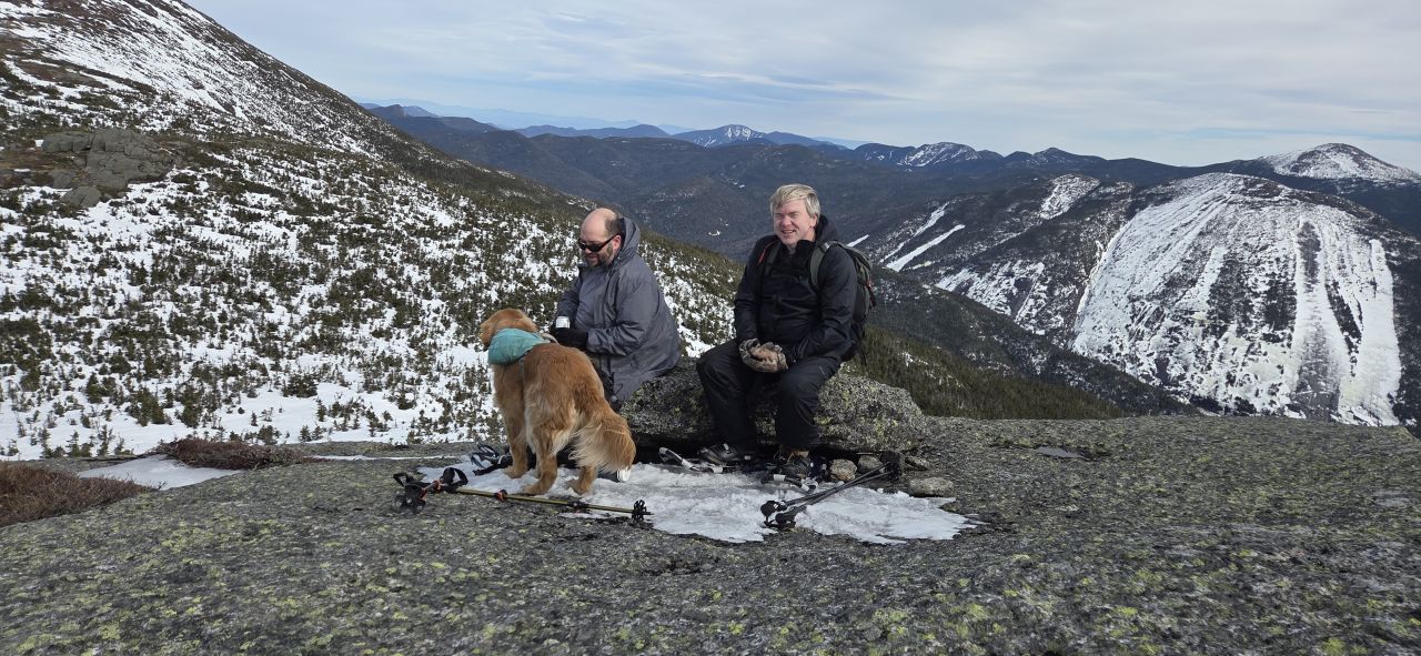
We eventually escaped to the lee of the summit and found the perfect boulder to sit on and have lunch, our snowshoes tucked under its lip. We ate, drank and enjoyed the awesome grandeur of a warm, sunny, Winter day in the Adirondacks.

I think we tarried on the summit until about 3:10 or so. After the food was eaten, Sunny was ready to head home. I was ready, too, but I am sure I'll be back here again and again.
My first butt-slide of the day was straight down Iroquois into the col between it and Boundary. I followed a line that one of the previous hikers had made before me. In the photo above you can see this line on the left curling down from the summit and into a little thicket of trees. Had I steered better, I'd have certainly made quite a bit further. I gauged that the softness and wetness of the snow was such that I'd be able to pick up good speed, but also that I'd be able to put on the brakes fairly easily as well. I was feeling good about the rest of the descent.


We found more spruce traps on the way back. I fell into a couple, but the monorail straight up collapsed under Dan at one point and Jay ended up in there with him. Sunny and I "helped".

We were back on Algonquin only 45 minutes after we started back from Iroquois despite the traps.
Zoom!
The time had come for the great lightspeed descent of Algonquin Mountain. We were starting to lose light, but the sun was still peeking through here and there. The air was still warm with the wind carrying gusts of even warmer air from time to time.

Every chance I got, I tried a butt-slide and today the sliding was fast indeed. We didn't get any photos of us butt-sliding, but we did take a bunch of video. I grabbed some stills from these videos for your viewing pleasure.

I didn't get any video of the big slide, of course. It was too long for anyone to wait anywhere to do a video and it was too dangerous to hold a phone while we were sliding. I will say, however, that it was incredibly fun. As predicted, the snow conditions were such that we could keep a good momentum during the slide, but we could also dig into snow with our shoes or poles in order to slow down or even stop. It was exhilarating and relatively safe.

Back at the ice cliff, Dan did a smart and climbed down via the path he'd taken up. Jay and I slid down the ice which was definitely a choice. All was well.
Interestingly, we met a guy summiting solo on our way down. After a brief chat, Dan said "Enjoy the sunset" as a parting gift and we continued our way down. I've heard him say this to people before and it doesn't get old.
In general, we made quick work of the descent. However, in our eagerness, we also each ended up buried in snow on the side of the monorail more than once.

At great length, we made it to the Marcy Dam/Loj junction where Jay and Dan switched to boots or spikes. I kept my snowshoes on because I really didn't want to put on my spikes and the ice on the trail here was soft enough that the teeth on the snowshoes would work just fine. We set off from the junction at around 6:10. I said that by all rights we should be able to make it to the register by 6:40 but I wasn't about to make any promises on my ability to keep up the 30 min pace. However, incredibly, we got to the trail register bang on at 6:40 meaning we'd descended from Al to the lot in 2 hours and 40 minutes.
Dan noted we were the last ones to sign out, meaning the lone gentleman we'd seen climbing Al a couple of hours ago hadn't signed in. Cool.

On the way out, we saw a car stopped on the side of the Loj Rd; people were watching the sun set over the Sawtooth range. We pulled over and took some photos ourselves. This one was taken by Dan.

Congrats to Jay for his first Winter High Peaks. I think he's got it in him to do all 46. Whether he wants to is a different story.
It was a fantastic day in the mountains. We got incredibly lucky with the weather today. I wouldn't call it perfect conditions, but it also wasn't anything to scoff at. Really, though, luck only partially had something to do with it; we also made good choices. Trail reports rolled in from other parts of the High peaks of people attempting Street & Nye or Cliff & Redfield only to be turned back by high water. We even saw a report that the high water bridge over Calamity Brook washed out that very day.
What's next? I definitely want to try and wrap up the Saranac 6, but I'm glad my original plan to finish those in the Winter were waylaid by, instead, climbing three high peaks with friends. I have no complaints there. If wintery weather makes a comeback, I'll try to head up and hike Scarface. Otherwise, I may have a couple of weeks of home projects before heading South to hike some Catskills. We shall see.
Route Map
