Grizzle Ocean et. al.
Jay and I made sure the campground was closed before arriving. When Putnam Pond is open, even if you're not staying at the campground, the attendant loves to check for your rabies vaccination paperwork and send you home if you don't have them. Off-season, they aren't necessary, but they're on my phone just the same.

We arrived at the trailhead mid-morning and were signed in at 10am on the dot. It was a glorious Friday October morning, a bit chilly but radiant and refreshing. Some rain was forecast for Monday, but we had lots of leeway on our schedule because Jay had planned a leisurely pace of about 5 miles each day.

Shortly after starting, the trail curls around the Southern tip of Putnam Pond (pond #1). At that point, there's a junction that can easily be missed. You bear right to go to some campsites and left to head into the back country. According to Jay, there used to be a post with a sign here, but that's gone now. I'm sure during the summer it's easier to see the trail bearing left, but it was nearly impossible in the fall. We eventually got our bearings and were on our way again.

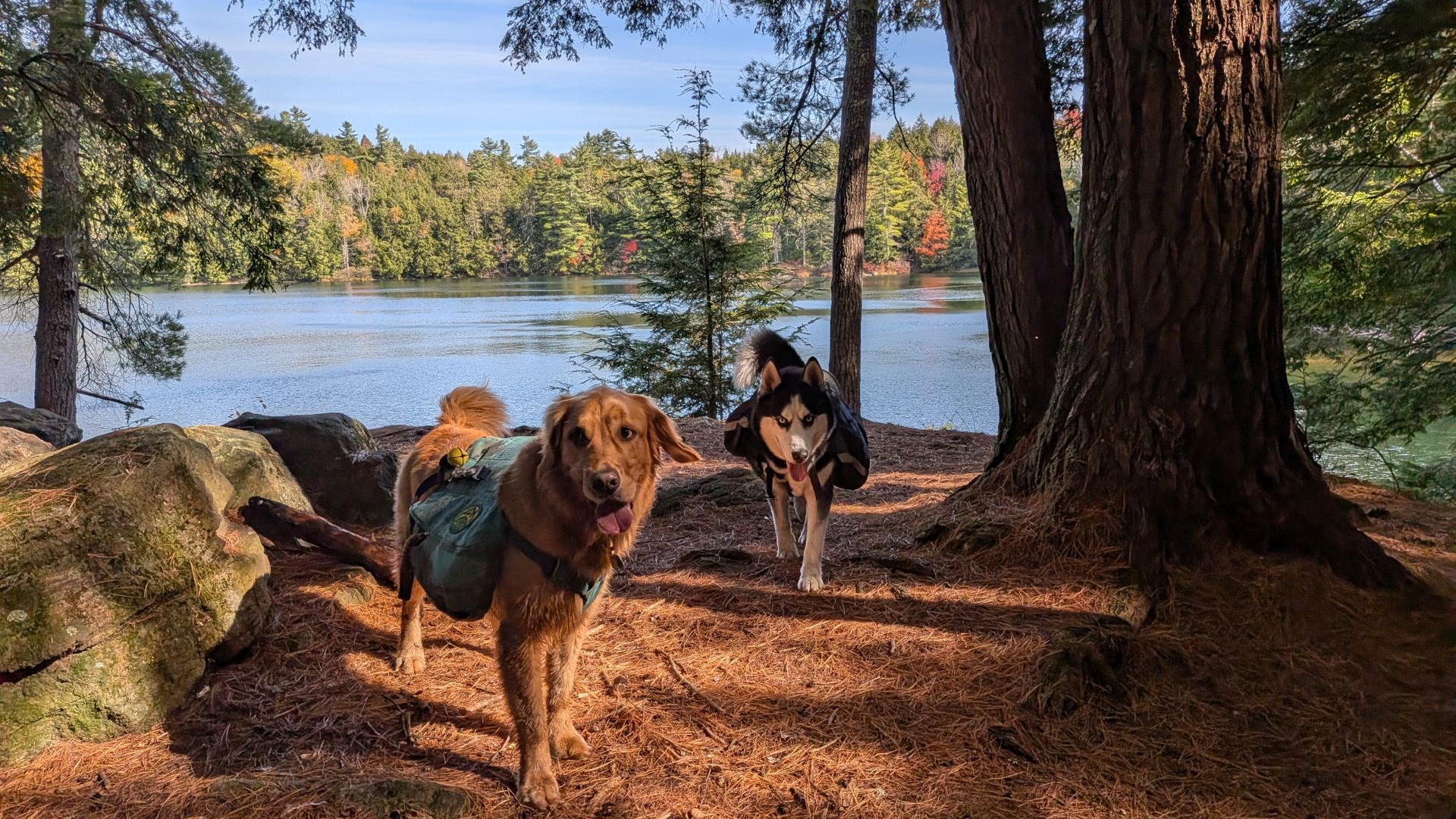
After a brisk hike through the flattish woods along rocky, leaf-covered trails, we turned left at the Treadway junction. After that, the duff underfoot grew softer and the trail soon came to the infamous "Grizzle Ocean". Thanks to Dan for this photo.

"Ocean." Pond #2.


Sunny was in great spirits pulling me along. At these lower elevations, I decided to keep him on leash in case of fauna or hunters. I wasn't really sure what to expect from the region because it's so alien to me. He had a great time regardless.

There was a bit of water to be had trickling from the little mountains. Still, most of the water to be collected in this region is from ponds and lakes, so be wary of what condition your filtration system is in and keep your hands clean.
The smells of fall were permeating the air throughout our hike and the colors were far more vibrant than I was expecting. Clearly, the High Peaks are well past peak, but this weekend the Pharaoh Lake region was quite pretty. I could feel the anxiety of the past weeks draining from my body as we hiked on.


The trail zigzags a bit around a short spur and Wolf Pond Swamp before coming to Wolf Pond itself (pond #3) which is a rather unremarkable but pretty body of water.


White pines dominate the area approaching Pharaoh Lake. This was a really interesting section of the trail. Dan said many of the trees there are well over a century old. It's nice to see forests starting to look like they did before industry decimated them.
Pharaoh Lake
A little over five miles and 2 and a half hours after we started, we were at Pharaoh Lake lean-to #4. The structure is in great condition, but has a busted-up steel canoe filled with holes hanging out behind it. The nearby latrine was an outhouse and it was in good condition, but was nearly full.
Oddly, there was a whole bunch of gear in the lean-to including a hammock, stove, fuel, food, badminton racquets, fly fishing gear, and more. There was much discussion and speculation throughout the day about the location and status of our potential bunkmate.

It was a glorious day. I was sweaty and warm and the breeze off the lake felt good. In the shade, the guys put on jackets.

We took our sweet time unpacking and preparing camp, trying to be respectful of the other person's scattered gear.

We relaxed by the lake for a bit and caught some rays.

Camp slowly took shape. Nearby, Dan set up his hammock and Andrew set up his tent. Jay, Sunny, Zuko, and I would be in the lean-to. We kind of just left the mystery guest's stuff hanging up where it was.
Yes, I brought some festive Halloween lights.


We took some time to harvest some blowdown, and then we enjoyed camp while the sun was still up. Thanks to Jay for the photo of Sunny and me and to Dan for the photo of me making good decisions.


The lake and Dan were magnificent in the sunset.


Sunny was a little extra. As usual.


After Jay performed a quick bris, we sat by the fire and enjoyed each other's company and some choice beverages. The night was chilly, but not unbearably so; we got lucky that the wind died down considerably as the sun set. We were surprised to see at least three other campfires on the lake that night.
Our assumed bunkmate never materialized. Dan had posted on a backpacking group about it and one commenter said the gear has been there way back in August.
We got pretty good sleep, but whenever Jay or I would get up, the dogs would think it was fun times and we had to settle them down. However, all in all it was a restful night.

We took our time getting around in the morning, enjoying the leisurely pace Jay had planned.


It was promising to be a warm and beautiful day in the Pharaoh Lake region.

The pack had been cutting my armpits a bit on the hike in, so the guys gave me some more packing advice and I got things adjusted. Mainly what I changed was moving my bear can to the center of the bag vertically and also tightening the belt over my hips before pulling the load lifters into position.
My lower back had been aching yesterday, but I was pretty sure that was due to Sunny being tethered rather than from wearing the heavy pack.
We were packed up and ready to move by 10am.
Pharaoh Mountain

We wandered around the Northern bank of the lake through low deciduous woods and marshes and up into pines. Interestingly, an old paper Nat Geo map that Drew had didn't show a trail up here at all, but it was on my paper map and AllTrails.
We passed several lovely tent sites and chatted with a handful of folks along the way. The day was certainly shaping up to be warmer than yesterday and I was glad to have once again started light on layers.

The first junction along the way bypasses the Pharaoh Mountain summit. We hiked past this and took the junction to the summit. There was quite a bit of blowdown through there and almost all of it had been cleared. I wondered if there had been a microburst recently. One commenter on Facebook said that the blowdown had been nearly impassable last year. One massive tree still lay on its side across the trail and some blazes had been set to lead hikers around the obstacle.

There were also some planks to manage the rough terrain left by the twisted roots and craters. The dogs made use of the latter to get a drink more than once.

Speaking of the dogs, they were in a great mood. The weather was perfect for them.


They easily negotiated all the obstacles they faced...

...except for one which they could have done had Jay and I taken their packs off. The crack was just too narrow and it was just easier to give them a boost than go through the rigamorale of messing with their packs.

The climb was certainly steep and we faced several cliffs and steep drainages along the way. I was definitely sweating, but the pack was, in fact, sitting quite well and my back felt ok. I'm convinced that any back pain I felt during the hike was always due to having Sunny tethered.

I must have said "Oh good, I was worried there wouldn't be another climb" at least three times during the ascent.

We reached the summit around noon, two hours after we'd started and I felt pretty darn good. It was a glorious day at the summit with beautiful views of Vermont to the East.

I'd brought a flag and some signs to join the protests that were going on across the country that day. The guys agreed to join me for a photo.

Several groups were already on the summit and also joined us throughout our time up there. Everyone was really cool and the dogs got lots of pets. We remained on the summit until about 1pm. We'd been kind of toying with the idea of hiking to a farther lean-to tonight to avoid the rain on Monday, but we were probably already keen to stay at Oxshoe Pond as per our original plan.

As we descended we saw this old... kiln?

We also had some views on the way down. However, the descent itself was super rocky and a bit annoying. The carpet of leaves meant we had to be cautious about our footing on the loose rocks. We passed a few people coming up and we soon realized there was a fairly close trailhead to the North for accessing the mountain directly.

A neat, little cave on the way down.
Oxshoe Pond

A short time later, the land started to flatten out and Sunny was on an absolute tear. I think he ran twice as many miles as we walked that day. I probably should have tethered him, but he was just having the best day of his life.

The trail was very easy to follow and I got the impression that it was well-traveled.

We soon came to the Pharaoh Mountain Trail/Long Swing Trail junction. A left turn to the North is a 0.7 mile hike to a jeep-accessible parking and camping area at Crane Pond, or a 1.1 mile hike to an SUV-accessible parking area, or a 2.7 mile hike to the main Crane Pond trailhead.
We turned right and headed Southeast. Shortly thereafter, we crossed the little stream tumbling out of the Glidden Marsh. It's quite lovely spot with mossy boulders and fallen leaves.

Long Swing Trail is well-maintained and hardened, though the boulder steps were not entirely necessary here. In fact, they were really not necessary anywhere on the trail this weekend.

Dan captured this photo of the Glidden Marsh before we hit the next junction. Continuing Southeast would have taken us through the pass and back to Pharaoh Lake. Instead, we jumped on Short Swing Trail heading East towards Oxshoe Pond.

The hike into Oxshoe Pond is very pretty and easy to follow.

Short Swing Trail passes within feet of the Oxshoe Pond Lean-to, our home for the night. We arrived here at around 2:30, an hour and a half after we'd left the summit. This would be about the 11-mile mark for the weekend's journey. The roof was a bit spongy, but otherwise the structure was in good condition. As usual, perfect campsites were marked with "no camping" discs which is pretty much always annoying.
The only real complaint we had, though, was the privy (a full outhouse) was sinking in the back at an angle with a rotten floor. I chose not to use it at all; I brought my trowel after all.

Oxshoe Pond (pond #4 of the trip if we're not counting Glidden Marsh) is absolutely gorgeous. It features more interesting rock formations dotted with little caves, cliffs, a little marsh at one end, and gorgeous trees and shrubbery which were shedding red leaves. According to a google image search, all the red shrubbery surrounding the lake was actually blueberry bushes. We were jokingly calling the larger cave across the pond a "Bear cave", but I'd be shocked at this point if it actually wasn't.
The entire region has some really cool rock formations and crazy boulders scattered about. It really is a bit different from the High Peaks region with lots of cracked and tortured terrain, reminding me a bit of the area around Crane Mt. to the South. I wonder if it has more to do with the distance from the big mountains. Perhaps here the weird formations don't get covered by scree and soil as readily. At any rate, the entire backpacking trip featured cool things to look at.


I busied myself collecting firewood in the surrounding forest. It was quite pretty here and I enjoyed the task. When I got back, I had fun breaking apart and sawing the harvest.

Once again, we sat by the fire eating, drinking, and enjoying one another's company. There was some debate about whether the name of the pond was a mistake or do oxen actually get shoed. I was dubious about the latter, but upon investigation it does turn out that oxen can and do get shoed. However, due to the cloven nature of their hooves, each hoof gets two smaller shoes instead of one large one like a horse would. What's more, Oxshoe Pond does, indeed, look like a single "half" of an oxshoe.
We thought the wood would be devoured by the fire much more quickly than it did, but there was a lot of hardwood in the mix.


Sunny and Zuko were done. At least for now.

I slept okay, but by the time 5am rolled around I was about sick of lying down and my back hurt. At 5:30, I shuffled to the end of the lean-to and got in my relax-a-chair (still in my sleeping bag) and enjoyed the sunrise with Sunny.

It was fixin' to be another beautiful day.

It wasn't long before Sunny and Zuko were grabassing around camp again. At some point, Sunny found a dead fish on the shore and rubbed his head in the remains. He smelled awful. I threw a stick in the pond a few times to try and get the smell off. I had mixed results.

I couldn't resist taking over a dozen photos of Sunny among the blueberry bushes.
Moar Ponds!
After some discussion, we decided that we didn't want to hike in the rain tomorrow. Since Andrew had to be out by Sunday anyways, the decision was easy to make. We'd had a lovely time and it was only 6.5 miles to the trailhead with minimal elevation gain.


We were on-trail by 9am and the pups were full of piss and vinegar.

This part of the trail also boasted many intriguing rock formations littering its broken landscape to enjoy as we plodded uphill towards the next pond. The group was kind enough to let Sunny and me set the pace for most of the adventure. We were able to keep to the trail for the most part, though there were a few places where we missed a bend and had to make a hard right to get back on trail. Even with the foliage, however, it was always easy to find the trail, partially because this area boasts a lot of trail maintenance and any smooth-cut blowdown is a dead giveaway for the trail. Also, most of the trails are fairly well-marked.

There was still no shortage of beautiful foliage here.

After climbing about 200' up a rocky drainage, we came to Crab Pond (pond #5). It was another verdant place surrounded by mixed forest. It had a little stream running out from it, feeding Glidden Marsh and Haymarsh down below.
A short distance down the trail we passed Horseshoe Pond (pond #6). I don't think anyone got a photo of this pond, but it did seem to have a campsite on its pretty, little inlet. According to the DECinfo Locator, it is, indeed, a designated campsite.

We turned off Short Swing Trail for the Lillypad Pond to Rock Pond trail and quickly came to Lillypad Pond (pond #7). This pond featured a lean-to. The pond absolutely does not make for a good water source which we all remarked on upon investigation. However, according to the maps, we'd apparently crossed a stream between the lean-to and the junction. I don't recall if it was flowing or not.

The trail wound lazily through a valley along Rock Pond Brook. The brook was quite rocky but I recall the trail itself was pretty soft and nice to walk upon. We were greeted with a big, stunning body of water. Rock Pond (pond #8 of the journey) was quite a big body of water with lots of clean, rocky places for swimming or just dipping your feet in.

It was still an absolutely beautiful day to be on trail.

Sunny and Zuko were in their element as usual as the trail wound around past Little Rock Pond (pond #9), then Clear Pond (pond #10), then Mud Pond (pond #11).
All of the ponds here had signs posted welcomed anglers to fish for Brook Trout, but warned them not to use bait fish.

Around about the Treadway Mountain junction, I leashed Sunny. My back and shoulders had held up well since Saturday morning, but almost immediately Sunny's pulling took its toll on me. The last 120' elevation gain on the Grizzle Ocean trail killed me more than the mountain summit had the day before.

Despite the aches, I still took the time to enjoy the world around me.

"I'm ready for pizza, Dad! Let's go!"

We signed out at exactly 1pm, 4 hours and 7ish miles after we'd started that day.
Victorious Conclusion
The larger pack worked out really great, I'd say. The load was distributed much better and it wasn't stuffed to the gills. I can probably find ways to trim down my weight on individual items. I should buy a lighter battery pack for recharging my phone and I could probably trim down my relax-a-chair. Both of those things are rather big purchases. For non-high peaks camping, I should also buy a bear bag and learn how to hang it rather than using the bear can; I think that would reduce the weight and bulk significantly. I'll have a go at the external frame pack in the coming weeks and see how I like it and make a decision as to a path forward at that time.
I felt like my endurance was good, though Sunny's pulling while leashed takes its toll on my body. I may try to learn how to train him to heel better in those situations if I can find the time and if I can remember to do it.


After some post-hike investigation, it does seem that the more exposed sections of the Crane area are geologically similar to the Pharaoh Mountain region which is interesting. Both are clearly nothing like the exposed intrusive bedrock gnesis found in the High Peaks region. Instead, in the surrounding regions, we're looking at an absolutely mad mishmosh of broken metamorphic rock of sedimentary origin deposited over the aeons in different mixtures. There are a few spots in this region with some exposed intrusive bedrock, but it's mostly this wild cascade of piles and flows of rocks ground up and deposited by glaciers, then further broken down and washed downhill by erosion.

Someone got a wash immediately after the hike and no longer smells like dead fish.
I had an excellent time and would love to do another backpacking trip. If I can trim down 5lbs from the pack and 15lbs from myself, I think I'd be even happier. Jay is planning our holiday car camping adventure right now, though I'll be sure to report on more hikes in the mean-time.
Route Map
